School nearby 곡소장 공장
Viet Nam
School nearby 곡소장 공장
곡소장 공장
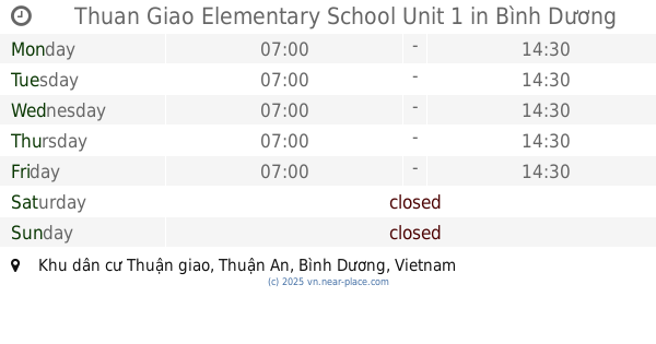
빈증, An Phú, Thuận An, Bình Dương, Vietnam
contacts phone
:
+84
Latitude:
10.9573759
, Longitude:
106.7317529
larger map & directions
read more
nearest School
586 m
Văn Phòng Gia Sư A+
Lê Thị Trung, An Phú
School
read more
813 m
Secondary School Nguyen Van Troi
Ấp 1B, Xã An Phú, Huyện Thuận An, An Phú
School
read more
829 m
Nhà Sách Hà Anh
Nguyễn Văn Trỗi, An Phú
School
read more
840 m
An Phu Primary School
An Phú
School
read more
1.173 km
Nhóm Trẻ Mẫu Giáo Tư Thục Hoa Cúc Xanh
3A/2, Cao Tốc, Phường An Phú, Thị Xã Thuận An, Tỉnh Bình Dương, An Phú
School
read more
1.208 km
Thuan Giao Secondary School
Thuận Giao
School
read more
1.275 km
Trường Mầm Non Tư Thục Sơn Ca
9/b2 Ấp 3 An Phú Huyện Thuận An, An Phú
School
read more
1.334 km
Eurasia English Center
An Phú
School
read more
1.545 km
Duc Tri Primary School
Thuận Giao
School
read more
1.546 km
Mầm Non BẢO NHI
thuan an, Bình Dương, An Phú
School
read more
1.549 km
trường cao đẳng nghề việt nam singapore
Thuận Giao
School
read more
1.715 km
Trường THPT Võ Minh Đức
Vòng Xoay An Phú, An Phú
School
read more
1.736 km
Tiểu Học Thuận Giao
Binh Duong
School
read more
1.756 km
Thuan Giao Elementary School Unit 1
Binh Duong
School
read more
1.769 km
Trường Mầm Non Kim Bình - Cs 2
Khu Dân Cư Thuận Giao, Thuận Giao
School
read more
1.769 km
Mầm Non Thánh Tâm
Unnamed Road
School
read more
1.825 km
MẦM NON PHƯƠNG HOA
Thuận Giao
School
read more
1.866 km
Trường Mần Non Thỏ Nâu
Thuận Giao
School
read more
1.898 km
Nhà trẻ Ánh Linh 3
Thuận Giao
School
read more
2.006 km
NGOẠI NGỮ GEMMA
Thuận Giao
School
read more
2.018 km
Trường Mầm Non Thỏ Nâu
Khu Dân Cư Thuận Giao, Thuận Giao
School
read more
2.068 km
Trường mầm non Thiện Ân
8/B2, Bình Dương, Thị xã Thuận An
School
read more
2.108 km
Trường Mầm Non Thanh Nhã
Khu Dân Cư Thuận Giao, Thuận Giao
School
read more
2.156 km
Đại Học kĩ Thuật Công Nghiệp Bình Dương
Thuận Giao
School
read more
2.337 km
Trường Mầm Non Búp Sen Hồng
1 Bùi Thị Xuân, An Phú
School
read more
📑
all categories
Accounting
Administrative area level 1
Administrative area level 2
Airport
Amusement park
Aquarium
Art gallery
Atm
Bakery
Bank
Bar
Beauty salon
Bicycle store
Book store
Bowling alley
Bus station
Cafe
Campground
Car dealer
Car rental
Car repair
Car wash
Casino
Cemetery
Church
City hall
Clothing store
Colloquial area
Convenience store
Country
Courthouse
Dentist
Department store
Doctor
Electrician
Electronics store
Embassy
Finance
Fire station
Florist
Food
Funeral home
Furniture store
Gas station
General contractor
Grocery or supermarket
Gym
Hair care
Hardware store
Health
Hindu Temple
Home goods store
Hospital
Insurance agency
Jewelry store
Laundry
Lawyer
Library
Liquor store
Local government office
Locality
Locksmith
Lodging
Meal delivery
Meal takeaway
Mosque
Movie rental
Movie theater
Moving company
Museum
Natural feature
Neighborhood
Night club
Painter
Park
Parking
Pet store
Pharmacy
Physiotherapist
Place of worship
Plumber
Point of interest
Police
Post office
Premise
Real estate agency
Restaurant
Roofing contractor
Route
Rv park, camping
School
Shoe store
Shopping mall
Spa
Stadium
Storage
Store
Subpremise
Subway station
Supermarket
Taxi stand
Train station
Transit station
Travel agency
University
Veterinary care
Zoo
administrative area level 3
sublocality level 1
↑