School nearby Trường mầm non Thiện Ân
Viet Nam
School nearby Trường mầm non Thiện Ân
Trường mầm non Thiện Ân
Bình Dương, Thị xã Thuận An, VN Vietnam
contacts phone
:
+84
Latitude:
10.9676818
, Longitude:
106.7159775
larger map & directions
read more
nearest School
250 m
Đại Học kĩ Thuật Công Nghiệp Bình Dương
Thuận Giao
School
read more
304 m
MẦM NON PHƯƠNG HOA
Thuận Giao
School
read more
409 m
Trường Mầm Non Thỏ Nâu
Khu Dân Cư Thuận Giao, Thuận Giao
School
read more
440 m
Nhà trẻ Ánh Linh 3
Thuận Giao
School
read more
489 m
Trường Mầm Non Thanh Nhã
Khu Dân Cư Thuận Giao, Thuận Giao
School
read more
561 m
Trường Mầm Non Họa Mi
Thuận Giao 6, Thuận Giao
School
read more
581 m
NGOẠI NGỮ GEMMA
Thuận Giao
School
read more
693 m
Trường Mần Non Thỏ Nâu
Thuận Giao
School
read more
737 m
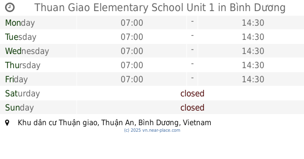
Thuan Giao Elementary School Unit 1
Binh Duong
School
read more
746 m
Tiểu Học Thuận Giao
Binh Duong
School
read more
850 m
Trường Mẫu Giáo Hoa Mai 4
Thủ Khoa Huân, Thuận Giao
School
read more
909 m
Thuan Giao Elementary School Facility 2
Thuận An
School
read more
1.09 km
Trường Mầm Non Trường Sa
Khu Dân Cư Thuận Giao, Thuận Giao
School
read more
1.116 km
Trường Mầm Non Kim Bình - Cs 2
Khu Dân Cư Thuận Giao, Thuận Giao
School
read more
1.183 km
trường cao đẳng nghề việt nam singapore
Thuận Giao
School
read more
1.32 km
Thuan Giao Secondary School
Thuận Giao
School
read more
1.383 km
Binh Thuan Primary School
Thuận Giao
School
read more
1.453 km
Trường Mầm Non Sao Mai
Đường Không Tên, Bình Chuẩn
School
read more
1.651 km
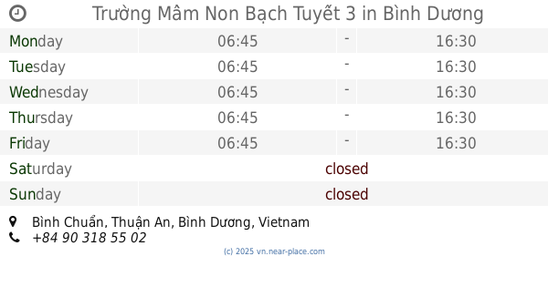
Trường Mầm Non Bạch Tuyết 3
Bình Chuẩn
School
read more
1.687 km
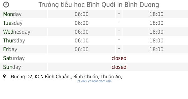
Trường tiểu học Bình Quới
Đuòng D2, KCN Bình Chuẩn,, Bình Chuẩn
School
read more
1.798 km
Trường Mẫu Giáo Chim Non
Thuận Giao
School
read more
2.068 km
곡소장 공장
빈증, An Phú
School
read more
2.34 km
Secondary School Tran Dai Nghia
An Thạnh
School
read more
2.36 km
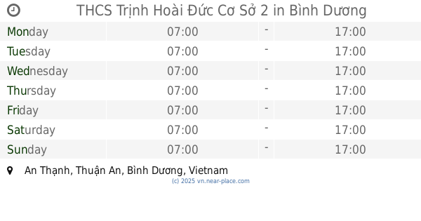
THCS Trịnh Hoài Đức Cơ Sở 2
An Thạnh
School
read more
3.455 km
Trung tâm Dạy Kèm Luyện Thi Đại Học Bách Khoa
An Thạnh
School
read more
📑
all categories
Accounting
Administrative area level 1
Administrative area level 2
Airport
Amusement park
Aquarium
Art gallery
Atm
Bakery
Bank
Bar
Beauty salon
Bicycle store
Book store
Bowling alley
Bus station
Cafe
Campground
Car dealer
Car rental
Car repair
Car wash
Casino
Cemetery
Church
City hall
Clothing store
Colloquial area
Convenience store
Country
Courthouse
Dentist
Department store
Doctor
Electrician
Electronics store
Embassy
Finance
Fire station
Florist
Food
Funeral home
Furniture store
Gas station
General contractor
Grocery or supermarket
Gym
Hair care
Hardware store
Health
Hindu Temple
Home goods store
Hospital
Insurance agency
Jewelry store
Laundry
Lawyer
Library
Liquor store
Local government office
Locality
Locksmith
Lodging
Meal delivery
Meal takeaway
Mosque
Movie rental
Movie theater
Moving company
Museum
Natural feature
Neighborhood
Night club
Painter
Park
Parking
Pet store
Pharmacy
Physiotherapist
Place of worship
Plumber
Point of interest
Police
Post office
Premise
Real estate agency
Restaurant
Roofing contractor
Route
Rv park, camping
School
Shoe store
Shopping mall
Spa
Stadium
Storage
Store
Subpremise
Subway station
Supermarket
Taxi stand
Train station
Transit station
Travel agency
University
Veterinary care
Zoo
administrative area level 3
sublocality level 1
↑